
|
The best convective days can often happen when you least it expect it and that's exactly what happened on May 14th when thunderstorms were the last thing on my mind. I had been looking at the charts and did see some instability over central and eastern N. Ireland however SB CAPE values were very weak, so weak in fact that I decided that the chances of anything cool happening were probably too low to justify a full day's driving, I also suspected cloud tops could be low or warm and so any towers would likely be capped anyway.
It did look to be a great day with warm sunshine and blue skies with fair weather Cumulus, the television forecast gave a dry day with just a very low chance of a shower. I decided to make the most of this fine day to continue painting my Mum's garden fence, I had been after a series of dry days to make some progress and had made a good start and wanted to get a little further on. So I got to work painting and lost in a world of my own enjoying the sunshine and relaxing with my attention focused on the small details of the job. Annoyingly a very high based Cumulus Congestus seemed to form rite over the house and was surrounded by blue skies, I couldn't believe it, then it began to rain, I thought it would pass so I kept on painting but the shower seemed routed to the spot. I never stopped and after 15 minutes of rain I was completely soaked, then hail stones began to bounce off the fence and for once I cursed the sky, this had completely undone all my work and the paint was beginning to run. Eventually after what seemed like forever the shower passed and dry weather returned so I continued painting.
By late afternoon I had finished what I could and noticed just how intense the sunshine was, I mean it was darn strong, I felt like I was cooking under it, the solar heating was the best I had felt all year yet above was clear blue skies, the storm chaser part of me thought it was a good waste of heating, why can't we get this kind of lift on a storm day when we need it. I was packing up with the intention of driving back to Cookstown when suddenly I noticed several well formed Towering Cumulus some distance away to the east, one cell in particular looked to dominate the skyline and I became fixated, could it actually do something? I decided to go on a local chase out the Crewe Road north to get a better view but trees blocked the horizon and by this stage the convection actually looked borderline impressive. The chase was now on, this had become an unexpected target, I turned around and drove south east to get a better look.
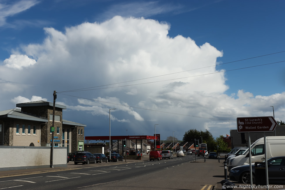 |
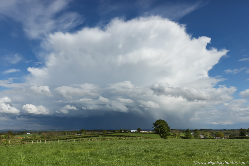
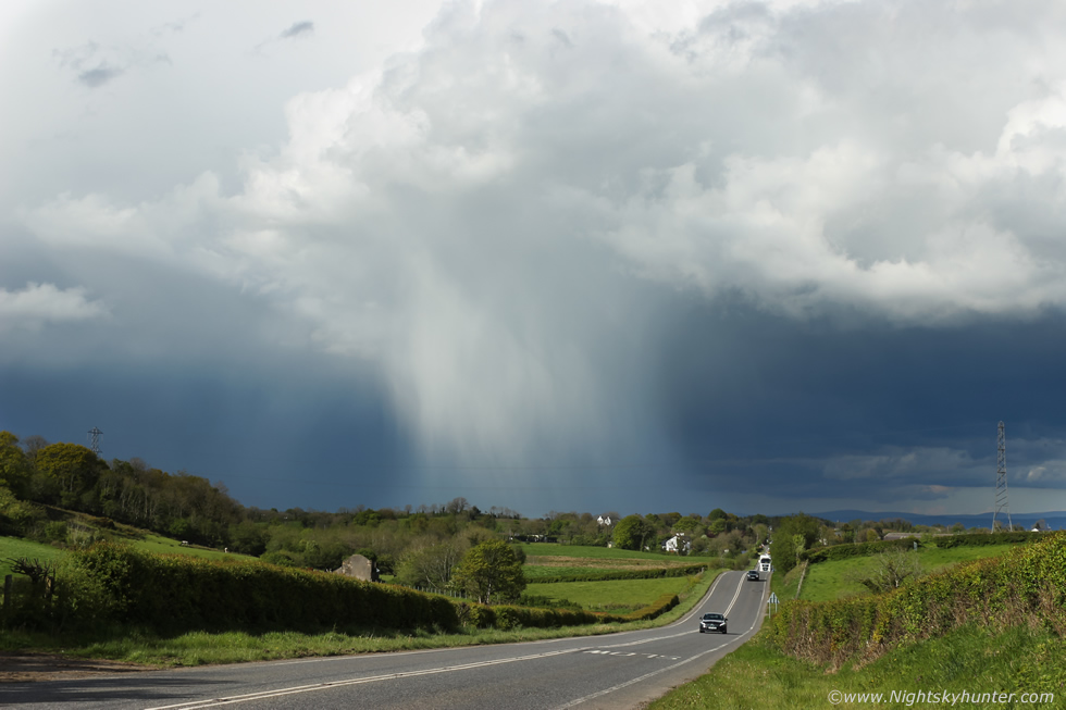
As I passed through Maghera the cell seemed to explode, I quickly pulled over not far from Crawford's filling station for a few shots, by this stage the cell was now taking up a large sector of sky, I hadn't seen any radar so I didn't know what it was doing but visually it looked the part, to me it was obvious the capping inversion had been overcome, likely due to such strong surface heating. The towers were glaciating into an anvil which was in the process of spreading out aloft, below the precip had become stronger with shafts of hail, this was a thunderstorm, it had to be. I jumped back in the van and gave chase.
 |
Driving south along Glenshane Road towards Castledawson roundabout, I was recording video with the window mounted Go Pro, the cell was dominating the entire sky, there was nothing else of note in the area so it looked like it was going to have all the energy and instability to itself.
 |
I pulled over onto a tractor path and got out for more images, it was difficult to get a clear view due to the random trees here but there was nothing I could do about those. The main road was to the right and to the left was a river with steep bank so I couldn't get away from the trees. I shot four images then ran back to the van and hit the road once more.
 |
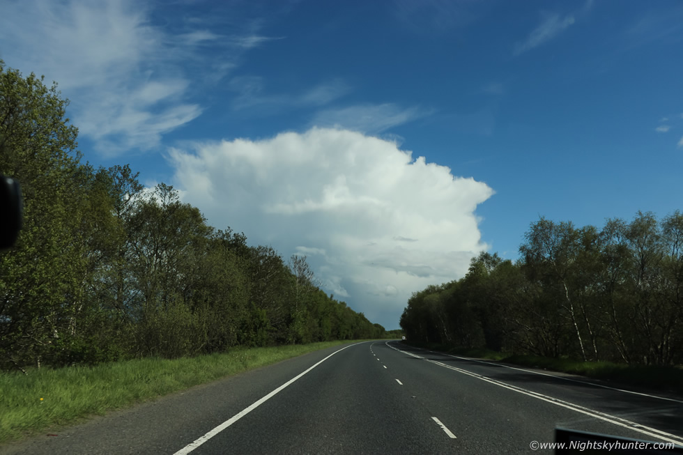
Driving south and the cell looked like a white mountain in the sky, I was actually really shocked by what I was seeing given the low instability, I was thinking maybe the models got the CAPE values wrong. I wasn't sure what way to go, at the roundabout I could go east to Toome but I would be stuck on a major carriageway in busy traffic with few options to pull over, then suddenly I saw a turn off to my left for Knockloughrim so I took it on pure instinct.
 |
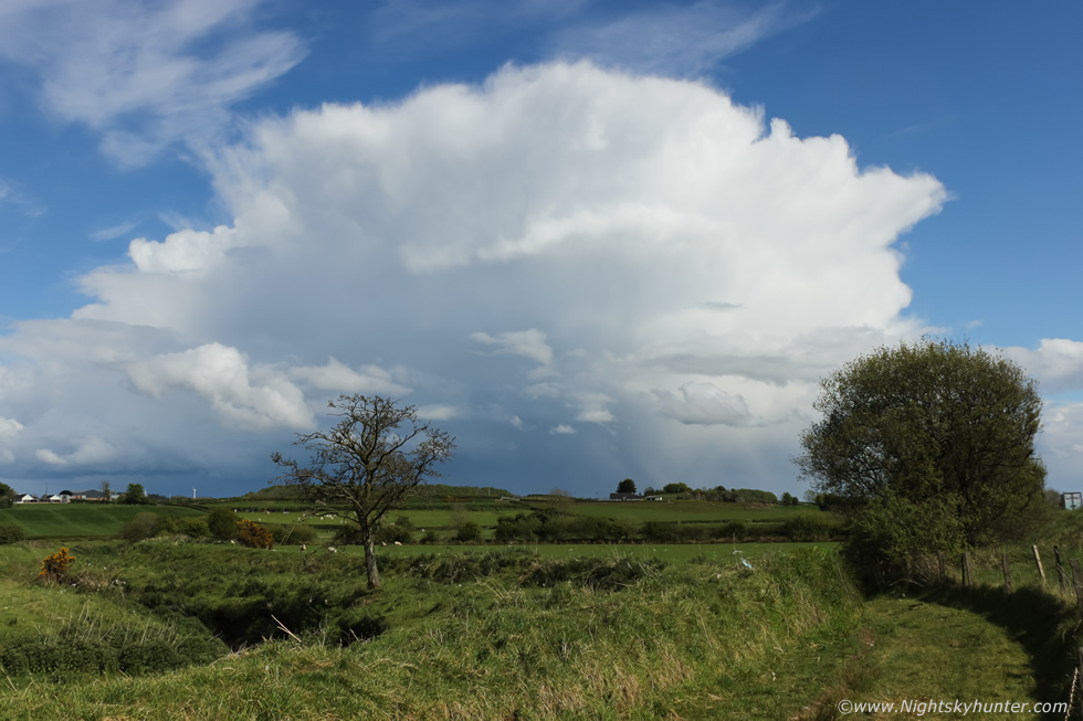
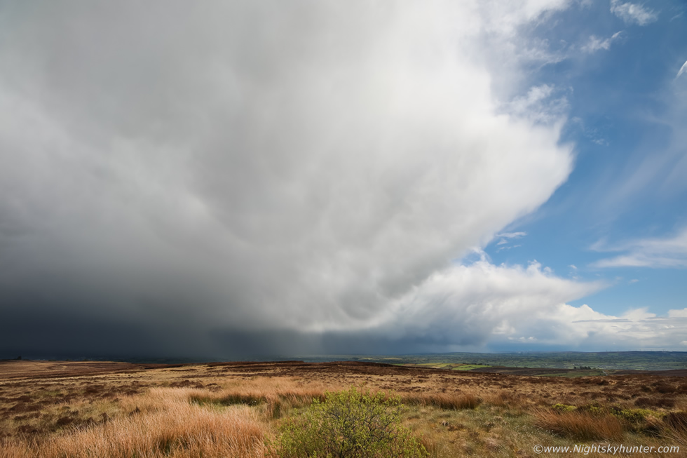
It was taking me in the rite direction and once I passed the hill I recalled the area very well as I had chased a cell here two years ago and had found a great wide open vantage point outside the village and this is exactly where I ended up and the timing was perfect. I pulled in beside a gate and jumped over into this vast open field with a scenic view across the eastern skyline and perched above it was a thunderstorm. The heat was stifling in this field with the strong scent of grass and trees in the air, it was hot and calm and silent, then thunder rumbled across the countryside, I was delighted, this was the first thunder I had heard all year and it was the best sound in the world. I suspect this storm probably had been rumbling away the entire time but I never heard it due to driving on a busy road.
From what I could tell the storm was located over Co. Antrim between Ballymena and Ballymoney, I set up the tripod then began shooting a time lapse then sat down in the grass with the sun burning my skin and savored the view. This was a beautiful single cell thunderstorm of the pulse variety, there was no strong shear aloft to separate the updraught from the downdraught and enhance severity. Without wind shear the anvil spreads out evenly in all directions like a pancake and would look rounded from above, the life cycle is short, perhaps 20-30 minutes before the precip swamps the updraught base killing the storm, this is why these are known as pulse storms or pop corn storms. However with fabulous viewing and light like this who cares what the storm mode was because this was absolutely beautiful and now at its mature phase. A photogenic slow moving thunderstorm in full sunshine over lush fields and surrounded by blue skies, this ticked all my boxes.
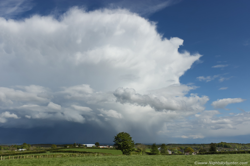 |
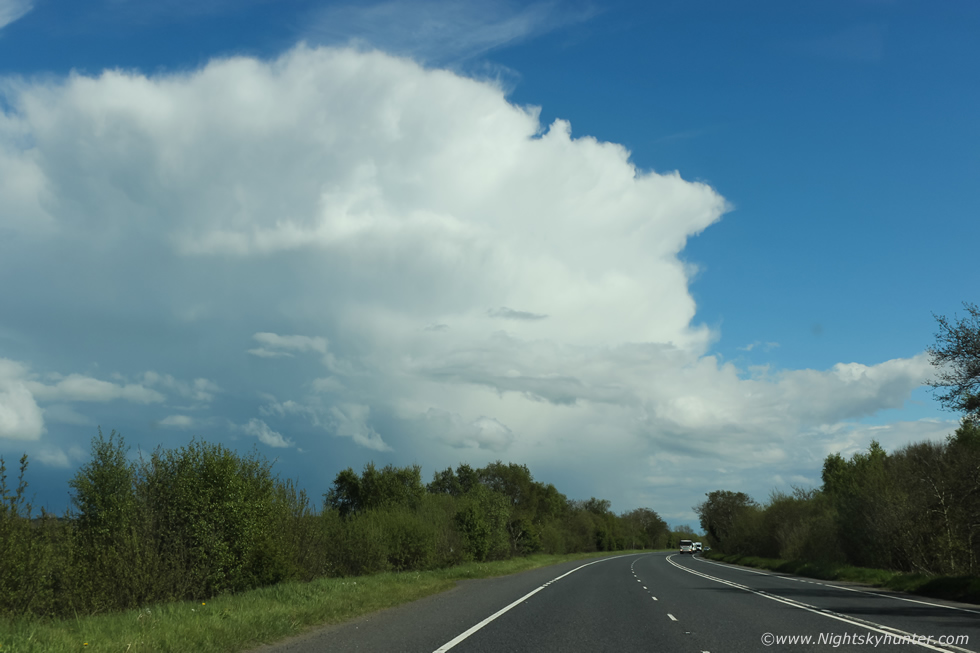
Zooming in slightly to the flanking region, storm moving slowly from right to left. Getting Summer thunderstorms in such great clarity of sky is rare and being able to see the entire cell with all its structure was the icing on the cake. To go from no chance of storms to this was a wonderful surprise from Mother Nature.
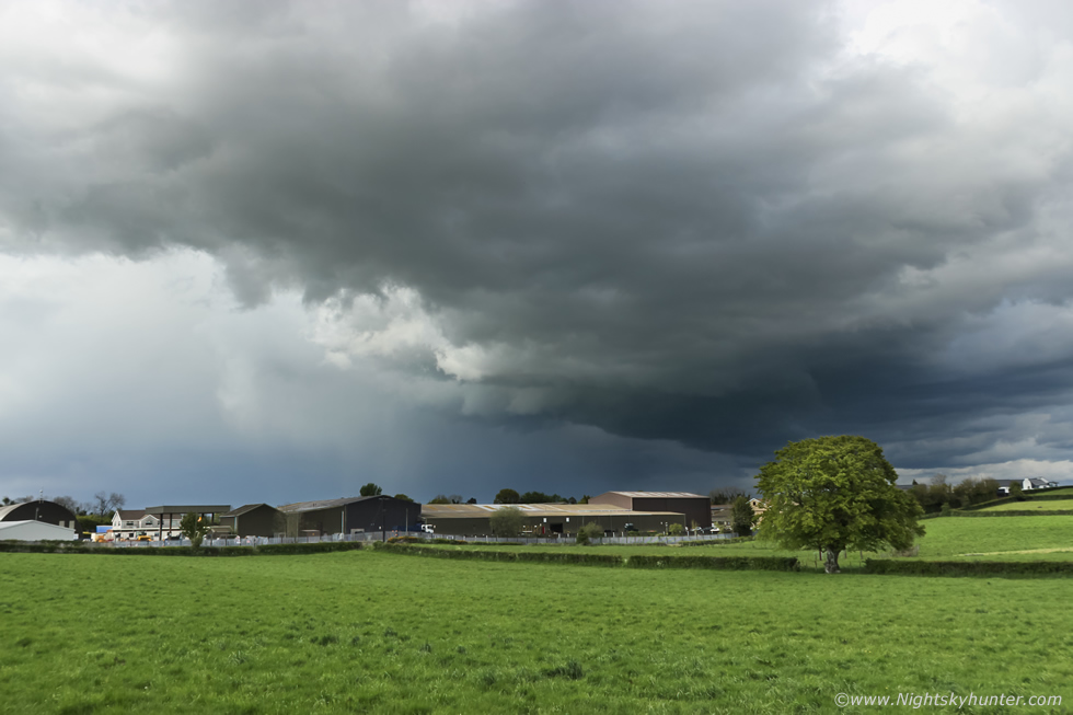 |
I began heading home when I spotted another cell, this time moving in from the Sperrins and east, this cell had formed on the outflow boundary of a spent cell behind it and was now pushing up high in the strong sunshine. I was on the road between Magherafelt and Desertmartin and needed to pull over for a look at the sky, I took a road off a small roundabout which I had never been on before in my life and ended up on a beautiful country road. This was the developing storm over a farm, the sky was mean and dark with robust clouds and strong core with hail, there was no thunder but I was watching carefully for funnel clouds. I was shooting stills from inside the van with the window down, it was stifling warm and the clouds were moving incredibly slow, I watched inflow rising and hoped for a funnel near that tree. That lowering in the middle and to the right was the area of interest but the structure had the early stages of a shelfy look about it suggesting outflow was dominating, still, it made for a nice image over the farm.
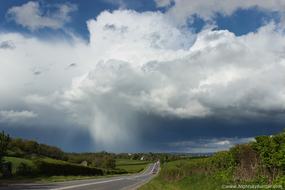 |
I continued driving home but the view in my wing mirror kept getting more impressive so I wanted a few more images, I was outside Desertmartin and didn't have any laybys to pull into so I literally drove onto the grass verge which was quite bumpy and rough ground, I really need a 4x4 for this kind of stuff, my mechanic is always telling me to avoid the grass ditches but with storm chasing you sometimes have to make these hasty decisions to get the shots. Cell dropping a strong core of hailstones, it amazes me how some people express shock at seeing hailstones in the Summer and often make claims about global warming and how they never had hail at this time of year before.
This is of course nonsense, Spring and Summer can produce sporadic but very intense hail events due to strong updraughts associated with convection and thunderstorms, remember those cloud tops up there where water droplets reside can between between -20c and -40c so water will freeze to hail rapidly, it then overcomes the strength of the updraught and falls to the surface due to gravity as the storm's outflow, this happens so fast it doesn't have time to melt so this is why hail is not uncommon this time of year, this image captures one of these events very well.
 |
Zooming in a little with the 18-55mm kit lens, a lens which I detest using as it isn't as sharp as a fast prime or higher quality zoom but its the only lens I have in this focal range which just so happens to be a great range for general storm scenes, I had this stopped down to F/8 which worked out very well for a hand held capture, this is as sharpest as this lens can get, the only way to get a fraction better is to use a tripod but I didn't have time for that. I really need a decent lens in the 18mm to 100mm range for both my crop sensor and full frame cameras. The cell moved east and out of range so I headed home more than happy with today's unexpected photogenic action. This cell would later become the second thunderstorm of the day in Co. Antrim and would be the main storm near Ballymena, storm chaser Colleen Webb obtained very nice video of the storm over great countryside with primary and secondary rainbows while thunder rumbled. This goes to show to never underestimate low instability set-ups on warm days.
 |
May 23rd was the last chase day of the month and it looked like one of those interesting warm core set-ups with promising synoptics with the usual concerns. 400-500 CAPE with 30-40 knots of deep layer shear and low cloud bases could produce funnel clouds and tornadoes and storms with supercellular modes so there was no way I was sitting in the house. Border areas had the strongest instability however Tyrone and Fermanagh also had good potential, the AROME was showing strong cells in these areas by early afternoon. I saw numerous showers formed on radar then made my way through Omagh then onto the high ground at Pigeon Top to intercept these cells. I watched them approach while time lapsing but they had no structure then when they hit I got treated to three periods of prolonged hail cores which were very impressive, garden pea size but bouncing 4ft in the air off the road and stone wall near the car park.
Once it passed Paul Martin met up with me and together we watched the skies, the back end of the cell line was the only photogenic catch of the day, the grey skies changed to sunshine and the landscape lit up as these anvils passed by. Radar indicated red cores with white inside with hail at this moment and the cores were sheared, it was beyond us why this wasn't producing thunder. I set up two wide angle cameras and shot time lapse sequences until the cells vanished over the Sperrins. We spotted a distant line of towers which looked promising but they all struggled aloft, it seemed warm air/weak capping has affected the tops of these cells. Later storms did fire to the SW of Dungannon and Armagh in the evening but there was no structure so the above image is all I have to show for this chase. I still enjoyed being out watching the skies, feeling the warm sunshine, taking in the scenery and munching on snacks, it sure beats any lock down!
 |
On June 10th a partial solar eclipse would be visible from N. Ireland for the first time since 2005 and I was keen to observe it. I really wanted to have a visual telescopic look with photography coming second place but I had no solar filters so I decided to construct an elaborate cardboard projection system on the Meade 90mm ETX so the solar disk could be viewed on a sheet of two A4 papers side by side. I spent a hot afternoon outside making the 'contraption' and although it worked like a charm it was an sight to look at it and slightly embarrassing, it was like the Frankenstein of projection set-ups, to tell you the truth I wasn't sure I wanted to be seen with it in public which is why I have no images to show you.
The night before the eclipse the forecast looked terrible, the eclipse would be best between 09.00 and 10.00 BST and although the afternoon was expected to brighten up the morning looked very bad. All forecasts gave cloudy skies during the main event. On the morning of the event I woke up early at 06.00 and the sun was shinning, I went back to bed then got up at 08.00 and it was like a different planet. As far as the eye could see was grey stratus clouds and it had that look of staying that way the entire time. I stayed optimistic and instead drove out to Davagh Forest to the newly opened OM Dark Sky Park and Observatory where I had planed to observe the eclipse from. Even if it stayed cloudy at least I would have a good experience trying from this exciting new location with a very bright future.
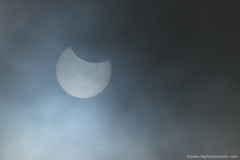
I wasn't alone, the observatory staff where also present including Mary McKeown who was the brains behind the entire project and members of the IAA including Paul Evans whom I haven't seen in years. Mary invited us into the observatory where we got treated to a tour of the exhibition area and the 14" telescope which we all enjoyed. We were offered tea and a great chat was had about Astronomy, meteors, fireballs, cameras and much more. An RTE film crew was also with us, Ed Finn presenter of the RTE travel series, I had met Ed here a year earlier and it was great to see him again. The skies were grey and mizzle splattered the windows. At one stage I had an instinct about the sky, a sixth sense that something was going to happen so I went back outside to the van and got the DSLR with 100-400mm lens, I selected the settings I suspected I might need then auto focused on a distant ridge of trees then changed to manual focus at 400mm, that way I would be focused on infinity and ready for action. I stood at the entrance to the observatory and suddenly the eclipsed sun appeared through the cloud, I gave a yell and everyone came out and saw it, for some it was their very first solar eclipse.
I had to select ISO 100, shutter 4000th/sec and aperture stopped down to F/16 in order to darken the sky enough to expose the disk with no filter, I composed the shot using the LCD screen and not the viewfinder so I was being as safe as possible. I got lucky and managed to capture ten images of the eclipse during its peak. We were all delighted and due to the cloud filtering the sun we were able to view the eclipse with the naked eye for a few seconds, we could all see the bite out of the sun which made the solar disk look like a pac man. Due to the fast shutter speed and F/16 I got a lot of dust spots on the images, these would never show any other time as I never use these settings so I had to spend some time in post removing as many spots as I could, but it was time well spent to get a record of the event.
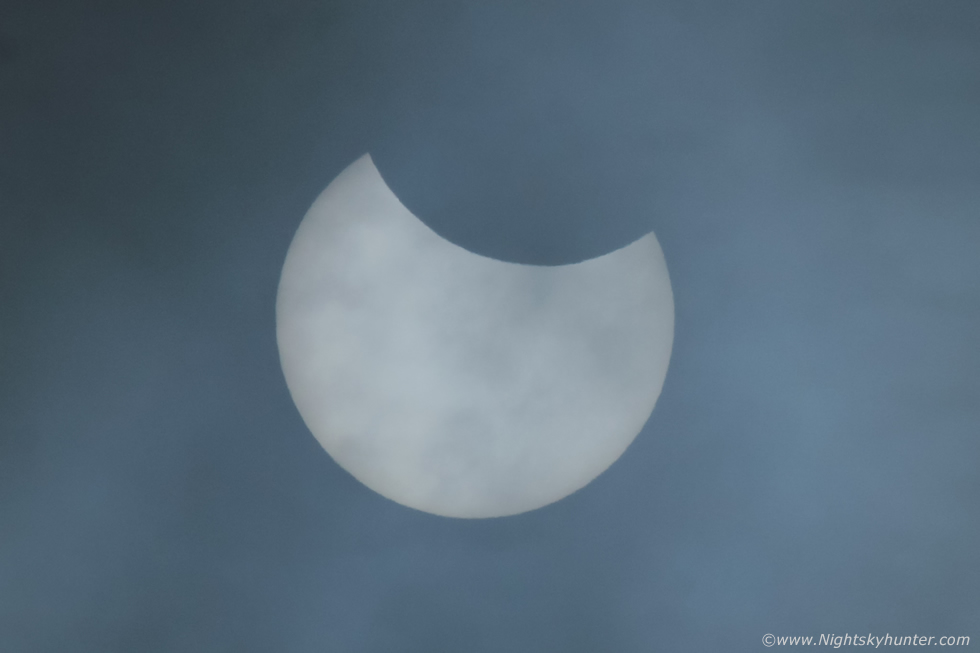 |
Crop from another 400mm still. This was the first significant Astronomical event from OM observed with the staff together and to me it felt like the observatory had finally been christened by the Universe.
Go Pro footage of the chase to the single cell thunderstorm from Maghera to Knockloughrim. It's now June and we have been treated to several weeks of fine high pressure weather, sunshine and warm days, there have been no more storms so June so far is turning out to be the most inactive convective month for many years but I'm hoping we will get our storms during July, August and even September. In the meantime we are now in Noctilucent Cloud season so I will be focusing my intention on time lapsing these amazing Mesospheric space clouds over the next two months. Thanks very much for reading.
Martin McKenna
